Beacon photo page's by Johan Veldhuis.
www.aerobeacons.nl
Luxeuil (Saint Saveur), NDB LXI, August 12, 2008
This beacon is located at the airbase at Luxeuil-les-Bains. This means that, although it is possible to get close to it, it is not allowed to take pictures nearby. Unfortunately, it was also very cloudy, which did not help for a good result. Oh yes, the text on the sign for non-French speakers:
It is not allowed to
draw/sketch, take pictures,
enter the terrain or
perform topographical actions
behind this border.
It goes without saying that the photos outside the delimited area were taken with a telephoto lens.
The quality is therefore not very good.
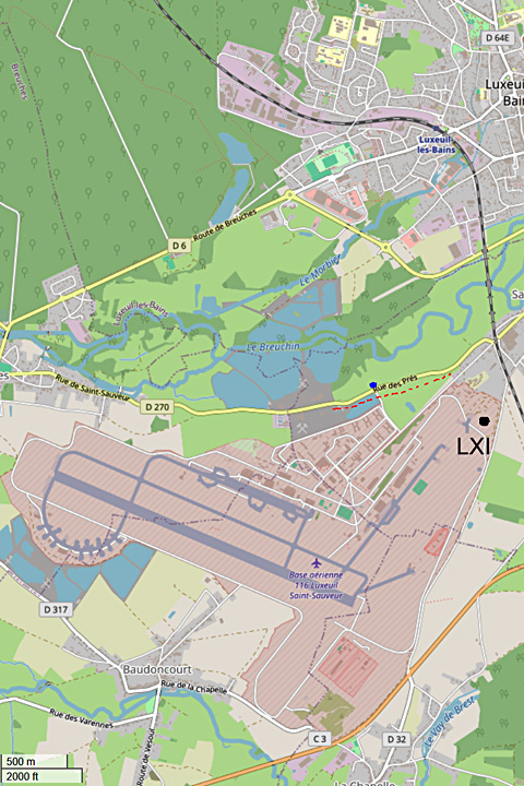
For clarity, a map of the area was made at home with the help of openstreetmap.org.
Route from Luxeuil-les-Bains to LXI, approx. 3.9 km – 7 min
Leave east on Avenue du Maréchal de Turenne/D6 to D6/Rue Victor Hugo and follow the D6 for 0.7 km.
Turn right onto D64e/Rue Edouard Herriot and follow for 0.5 km.
At the roundabout, take the 1st exit onto Rue Edouard Herriot/N57
After 0.6 km, at the roundabout, take the 1st exit onto D270/Rue du Maréchal Lyautey.
After 0.6 km, turn right onto D270/Rue des Prés and follow for 1 km.
Turn left towards Rue Georges Guynemer and after 0.4 km, turn left again onto Rue Georges Guynemer. You will find your destination on the right after 0.2 km –
Please note that you are past the border where photography is allowed.
To take photos, you must go to Rue des Prés.
This beacon is not on the GEN 2.5 list of 2024.

NDB LXI, August 12, 2008.


© openstreetmap.org